Kent Aerial Photography
The extended geophysical survey is supported by a trial project to make a new transcription of crop marks (Kent Cropmark Viewer prototype coming soon!) to correct shape distortion and positional errors in the data published in 1989 by the Royal Commission on the Historical Monuments of England. It will incorporate a considerable volume of new data from aerial photography flown since 1988 and include geophysical survey interpretation and simplified excavation plans where available. The trial covers two OS 100km square TR15 and TR25 that extend from Chartham in the SW corner through to the Ringlemere excavations in the NW corner.
These squares have been completed for vertical aerial photography and the oblique images held by the Cambridge University Collection of Aerial Photography are being examined to fill in gaps or missing details. The new transcription has identified a number of new sites or greatly improved the clarity of some known crop marks. These include the Ickham structures, a possible temple with cella, ambulatory, vestibule and portico east of Patrixbourne, a substantial number of ring ditches some of which have possible associated Anglo-Saxon cemeteries, windmill cross-trees and slit trench systems to name just a few.
Important discoveries have been sent to Canterbury Archaeological Trust for their records and are sent to Kent County Council for inclusion in the HER if they have not been previously recorded.
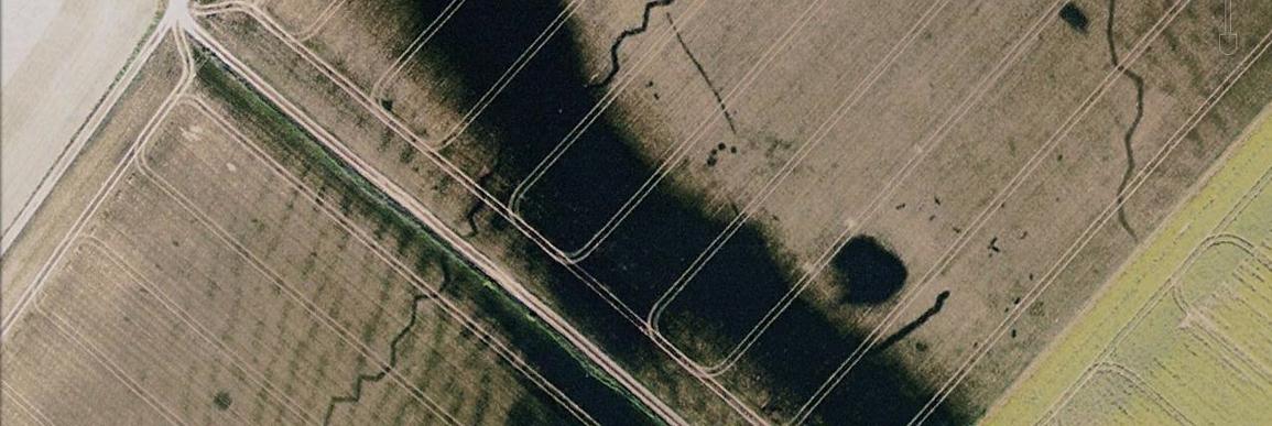
Example of the problems with the RCHME/NMP crop-mark data.

This image shows the raster NMP digitisation over the geo-corrected 1990 aerial images and MasterMap. Many of the features on the crop mark layer show up in these aerials.
Some NMP-digitised features have the correct shape and approximate location, others have one or the other and quite a few are so inaccurate as to be misleading. For example, the 'stomach-shaped' enclosure with two entrance ways is highly inaccurate in shape, size, and position. Another problem is lack of detail in the NMP work. For example the central partial-square enclosure that stops on the trackway in the centre of this image is, in fact, trapezoidal and continues on the other side of the modern track.
This part of the Project is being led by Chris Blair-Myers, supported by Lacey Wallace and Alex Mullen.
Crop marks in Kent: an introduction and discussion of the data
By Chris Blair-Myers
Crop-marks are the visible effects of vegetation responding to differences in available soil moisture and nutrients. Shown below is an aerial photograph of the golf course on the Sandwich Bay dune system taken in mid-summer after a dry period. The dunes form ridges running roughly north–south interspaced by low-lying slacks. The slacks are closer to the water table with a higher humus content and thus appreciably more fertile than the thin, free-draining, sandy soils on the dunes that rapidly desiccate in dry weather. The brown, parched grasses on the sandy soils can be clearly differentiated from the lush green sward on the slacks. The closely mown fairways show as brighter strips but have no impact on the crop-marks beyond improving the boundary definition.

Image courtesy of Google earth
Similar effects can be the result of sub-surface archaeological features that create variations in soil depth causing vegetation over these features to show differential growth or ripening at a different rate to the surrounding vegetation.

Shallow soils over a buried stone wall may impede root development, even under normal weather conditions, stunting plant growth in comparison to adjacent deeper soils. They will desiccate rapidly in dry weather causing stress to the vegetative cover. Conversely ditches have deeper soils more resilient to drier conditions often with higher nutrient levels over which vegetation thrives in comparison to adjacent shallower soils. Differential crop growth and parch-marks can be seen from the ground but it can be difficult to determine extents or identify patterns and are best seen from the air.
Positive crop-marks

Image courtesy of Kent County Council
The photograph above shows the crop-marks of ring ditches, irregular enclosures and field boundaries as differential growth in ripe wheat. The crop over the ditches is taller than the surrounding crop, the sun is placed in the bottom right corner. The taller crops are brighter where they face the sun with a distinct shadow on the opposite side. The effect becomes more marked when the sun is low on the horizon, accentuating shadows.

Image courtesy of Kent County Council
The photograph above shows the crop-marks of a double-ditched enclosure with a causewayed entrance with other non-contemporaneous boundaries in a field of ripening wheat. The crop is ripening more slowly over the moister ditch soils compared to the surrounding drier chalk soils. The outer boundary ditch of the enclosure can just be seen as a faint soil mark in the adjacent ploughed strip.

Image courtesy of Google earth
In the image above a double ring ditch and the individual grave cuts of an Anglo-Saxon flat cemetery are showing as positive crop-marks in young spring wheat sown on thin chalk soils. The crop is growing more vigorously on the deeper soils on the ditches.
Negative crop-marks or parch-marks

Image courtesy of Google earth
Above is a negative crop-mark or parch-mark in mown grass of a Roman building at Wye. The rectangular shape with room divisions is quite clear though the image has been enhanced using a contrast stretch to accentuate the feature; parch-marks are rarely this obvious. Below is a more typical example of a parch-mark. This is the small Roman villa in the grounds of Fairlawn Park, Plaxtol, barely discernible as a sub-divided small rectangular feature, just left of the centre of the photograph.

Image courtesy of Google earth
Negative crop-marks in crops are rarer. The 2013 image (below, left) shows three small circular features where the crop is stunted and pale, the 1946 image (below, right) shows these were once the concrete platforms of a WWII anti-aircraft battery.


Images courtesy of Google earth
Factors that influence the creation of crop-marks
If the key element is variation in soil moisture, the weather can be critical and periods of drought, particularly in late spring and early summer when vegetative growth is peaking, can produce particularly good conditions for crop-marks. Winter droughts may have little discernible effect as the vegetation is dormant and late summer droughts have little visible impact on ripened crops or grasslands that are already parched and browned.
In drought conditions the speed with which a crop-mark develops is very dependant on the nature of the soil. Soil consisting of coarse particles (sands) releases water readily to sustain plant growth, but can be exhausted abruptly. Crop marks on these soils can develop in a matter of days. Soils consisting of fine particles (clays) retain water, releasing the moisture to plants at a decreasing rate as they dry. The reduction in plant growth takes place over a far longer period and it may take several weeks for crop marks to develop, if at all. In both instances a fresh fall of rain would restart the whole process.
Even when weather conditions are favourable there are a number of other factors that militate against the appearance of crop marks.
Soil creep may reduce soil depth on interfluves, accreting in valley bottoms to a point where sub-surface archaeological features are too deeply buried to affect vegetation. Soil loss on the interfluves, exacerbated by frequent ploughing, may reduce or completely remove all but the most substantial archaeological features. On subsequent crop-mark mapping, this can give the entirely misleading impression that archaeological features are concentrated on the gently sloping flanks of valleys.
Images courtesy of Google earth
In the image above the dry valley (dark green/black) is only a metre lower than the surrounding land, but the difference in soil depth is sufficient to effect the crop growth, obscuring a section of the WWII slit trench that zig-zags across it.
Surface geology is an important factor. Where the composition of a ditch fill is very similar to the surface geology, as is often the case for clays or wetland soils, there is insufficient contrast between the ditch and the natural to create a differential effect on the vegetation except under the most extreme drought conditions. For this reason, there are very few crop-marks recorded in the Kent Wealden Clays. An excellent example would be the extensive Romano-British settlement at West Hawk Farm, Ashford. The site was revealed by geophysical survey conducted prior to the construction of a large housing development, but had not produced a significant crop-mark in ten different sets of aerial photography flown between 1946 and 2013.
Free-draining soils on alluvium, sands and chalk can provide a very marked contrast to ditch fills and, under ideal conditions, produce crop-marks of remarkable clarity. Parch-marks on these soils can be very fleeting, if they appear at all, as the soils desiccate rapidly. These soils cover much of northern and eastern Kent and for this reason the overwhelming majority of crop-marks recorded in Kent are ditches found on these formations.
The type of vegetative cover can be significant. Natural grasslands are habitats that are composed of a remarkably rich and complex mix of grasses and forbs adapted to the site conditions. For example, chalk grassland communities are particularly suited to hot dry sites and unlikely to produce parch marks even under drought conditions. The complexity of the species mix enables the community to accommodate seasonal fluctuations in the weather. What may be detrimental to one part of the community may cause the other to thrive and so there is no overall discernible difference in the vegetation when viewed from a distance.
Improved grasslands respond somewhat differently as they are species-poor and lack the adaptability of natural grasslands. Indeed, some grasslands are ploughed and sown with a very limited variety of grasses and clovers and respond more like a cereal crop. They are often mown for hay or silage, a short sward should add clarity to crop-marks, but they are usually cut early in the season when crop-marks are developing. Long grass, when freshly cut, can be uniformly yellow and thus hide crop-marks, although they can reappear when the cut grass recovers.
Pasture or amenity grassland, where the sward is maintained as short grass, can be more rewarding. Crop-marks in lawn are usually produced by parching. Negative marks appear first as the grass browns over buried walls and pavements, but if the drought continues, the grass browns over on the remaining shallower soils, leaving the ditches as greener positive crop-marks.
The images below show the structural complex at Bourne Park, Kent, appearing as parch-marks.

Image courtesy of Google earth
The photograph above, flown in 1990, revealed parch-marks in the northern corner of the closely mown cricket pitch at Bourne Park adjacent to the pavilion. The site sits on the alluvial floodplain of the seasonal Nailbourne stream and has been grazed or mown parkland since at least the mid-1800s.

Image courtesy of Google earth
2003 was a significantly drier year and the aerial photography was flown several weeks later than the 1990 images. The features visible in 1990 are fading as the grassland around it browns, but can still be seen. An additional set of features that were barely visible in 1990 were showing more clearly in 2003 as a T-shaped annex to the main corridor.
The real surprise came when the first geophysical survey results revealed not just the features seen in the crop-marks but a whole new range of rooms to the southeast and a number of substantial ditches. Clearly crop-marks may only give a hint of the subsurface archaeology, images taken in different conditions may reveal new features and the absence of crop-marks is most certainly not synonymous with the absence of archaeology.

Image: Canterbury Hinterland Project 2012
Crops are monocultures with little genetic variability developed to respond uniformly to weather and soil conditions to ensure the whole crop ripens at the same time. This uniformity of response is very useful as all the crop above an archaeological feature will behave in a similar way creating very clear crop-marks.
Not all crops have the same degree of sensitivity to soil conditions. Large crops like shrub or fruit orchards have deep and widely spreading root systems that reduce their sensitivity to localised variations in soil moisture. They still occur particularly where the sub-surface feature is broad, forms an impenetrable layer and is near the surface. In the examples below, flown in 1999 and 2003, the apples trees planted in the mid-1990s have failed to reveal a curvilinear feature.


Images courtesy of Kent County Council
With the notable exception of maize, cereals can generate excellent crop-marks. Their limited root depth and spread are sensitive to localised variations in soil moisture and the close planting of the crop gives good definition revealing small features in high-resolution aerial photography. The photograph below is taken of a field of spring wheat. The field boundary ditches and ring ditches are obvious but it is also possible to see a line of pits or post holes leading from the centre of the image directly to the large ring ditch. These pits are less than a metre across. Also note the lighter tone to the centre of the larger ring ditch suggesting that there is still a low mound that hasn’t been completely ploughed out. The two small rectangular features in the centre of the image, of which the largest measures 5x3 metres, may be sunken buildings.

Not all crop-marks are archaeology
Although the aerial photograph of the Sandwich dunes illustrates vegetative responses to differences in soil moisture that are natural in some instances, they can look remarkably like archaeological features.
In north Kent, the Thanet Beds are formed of layers of clayey sands, sands and calcareous sandstones in thin beds. Where laid horizontally and eroded the small variations in soils can create patterns that look like archaeology. In this photograph below, the resulting pattern looks remarkably similar to the banks and ditches of a small iron age fort.

Image courtesy of Kent County Council
Periglacial action on clays and sands can produce distinctive geological patterns, this includes the polygonal ice wedges commonly found on the London Clays in north Kent. They are strikingly similar to pre-historic field boundary ditches as can be seen on the image below from the Hoo Peninsular. Note the two faint ring ditches adjacent to the quarrying and that the ice wedge polygons pass through them.

Image courtesy of Google earth
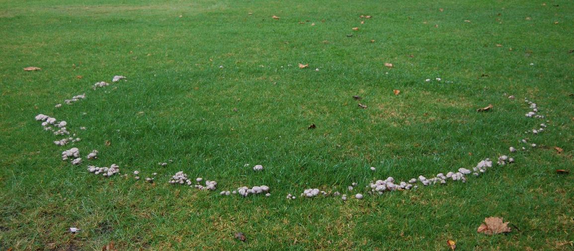
Crop-marks of ring ditches particularly in grass can be attributed to a number of other possible causes. In the image below, there appears to be a ring ditch some 18 metres in diameter showing in a mown meadow in 2003. Looking at the same site in 1990 (lower image) there is still a ring ditch but this is much smaller at 10 metres across. Another image taken in 1999 (not shown) shows the ring ditch 15 metres across.


These rings are created by fungi and are more commonly called 'fairy rings'. There are a number of species responsible, some have no visible effect on the grass but others locally increase available nitrogen creating a positive crop-mark whilst in another group the associated bacteria coats the soil with a waxy substance making the soil particles hydrophobic creating a parch mark. The photograph below shows a small ring formed by Blewit fungi; the ring expands with each growing cycle.
Negative rings can be associated with equestrian training where the pony is led around in a circle on a lunge (a fixed length rope or strap). This leaves a hard trodden circular track that can persist long after the training activity has moved elsewhere and will often appear as a parch mark in dry weather. The image below is probably more obvious than most and the presence of fields subdivided into paddocks can be another useful indicator of the likely cause on the smaller ring in the un-grazed pasture.

The group of circular features shown below are perched on top of a chalk ridge and could be taken for a cluster of ring ditches, but are the result of grazing ponies tethered to central posts.

Other circular features can be found in old sports fields where repetitive white lining of football pitches, especially around the central circle, can compress the soil leaving parch-marks in dry years long after the field has changed use.
Finally some find it hard to resist the creative urge to create their own crop-marks, the example below shows what you can achieve with a lawnmower and an impressive spatial awareness.