The Flag Fen Archaeology Park which contains preserved parts of the timber monument. Image from City Culture Peterborough.
Flag Fen Blog 4 – Week Three
Trench 3 – A Second Picture of the Post Alignment
After starting our second trench that would examine the wooden causeway (the confusingly named Trench 3!) we continued to remove the sediments that sat above and around the upper layer of timbers. It was a tricky start to the week, with the weather proving to be both damp and windy, conditions that made excavation challenging. Despite being unpleasant to dig in, at least the rain helped to keep the wood wet! However, by the middle of the week we were back to regular spraying to make sure that the wind wouldn’t dry out the timbers.
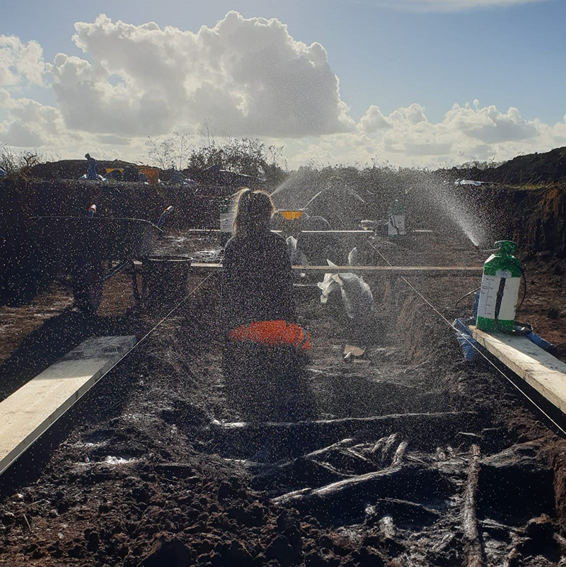
Windy conditions can cause exposed wood to dry quickly so we’ve been making good use of the sprayers to keep the timbers damp.
With Trench 2 moving from the excavation to recording stage, most of our attention this week focused on getting Trench 3 to the same place. This required the team to work quickly, which is not an easy task when working with wood from the later Bronze Age. As we began the process, we came across a fairly dense area of upright posts, which meant we had to use trowels to painstakingly remove the peat from around them. We soon revealed the first layer of horizontal timbers and, as with Trench 2, noticed that one end of Trench 3 had less wood, suggesting we may have found the limit of the deposit in this area.
Archaeology is usually associated with the discovery of artefacts, but it is important to note that this is not always the case. In Trench 2 we found a small number of typical Bronze Age finds, including flint, pottery and animal bone, but while uncovering the timbers in Trench 3, we came across no other material culture except for the wood itself. Evaluations by design only expose small areas of archaeology, in this case approximately 0.45% of the monument. It is clear from these two trenches that within this upper deposit there are currently few finds emerging.
By the end of the week, we had managed to expose and clean the complete layer of wood in Trench 3. We’re very lucky on this project to have a talented and hard-working team of archaeologists and it is always hugely satisfying to stand at the end of a trench and see the results of several days delicate digging and cleaning.

Trench 3 looking clean and ready for its close-up! Each trench that is part of the evaluation is recorded using traditional record photography as well as photogrammetry, which creates detailed 3D models of the archaeology.
In our last blog we discussed how we’re using photogrammetry to help us document this evaluation’s archaeology and generate the plans that form the basis for our wood recording. Alongside this technique, we also use more traditional record photographs to help us capture the project’s archaeology. We’re fortunate enough to have one of the Cambridge Archaeological Unit’s photographers, David Matzliach, working as part of the team and he’s been providing us with some fantastic images.
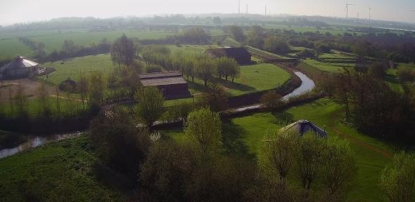
Photographing the wood and the archaeology we’re investigating is not an easy task. The trenches we’re using for the evaluation are 20m long, the light conditions in these early winter months are always challenging and, finally, the timbers are intertwined and complex. Thankfully, we’re able to get a good overhead perspective of the archaeology using a drone.
Overhead shots are really important as this viewpoint gives us the chance to see the entirety of the exposed archaeology collectively, including the vertical and horizontal elements. When working on smaller-scale evaluations like this, it’s important to remember we’re only seeing fairly thin (1.5m wide) strips of archaeology, so identifying patterns can be problematic. However, an overhead perspective is still valuable and can potentially help us identify elements within the timbers that may not otherwise be obvious.

Using the drone for photography enables us to get different perspectives of the archaeology and quickly and easily see the entirety of the evaluation’s trenches.
Project Information
Historic England is funding the project to create a management plan for the protection, understanding and enjoyment of Flag Fen and this historic landscape for generations to come.
The evaluation work is being carried out by the Cambridge Archaeological Unit, finds and conservation assistance is provided by the York Archaeological Trust and the project is supported by Anglian Water, City College Peterborough and City Culture Peterborough.
Digital engagement for the project is kindly supported by the White Rose College of the Arts & Humanities, the AHRC and the University of York, Department for Archaeology.
Flag Fen Blog 3 – Week Two
Trench 2 – Progress on the Post Alignment
Week Two saw us starting the week by concentrating on uncovering and defining more of the timbers that make up the wooden causeway. In our last blog we described the challenges of doing this, as waterlogged wood is a delicate material requiring a great deal of care and attention to expose and clean.
When we began working on the 1.5m transect down the centre of Trench 2, we started in the centre and worked outwards. This might seem like a curious decision but beginning in the middle of the trench, directly above the timber causeway meant we would be able to quickly discover the depth of the wood. If we’d opted to start at the edges, there would be no guarantee that the post alignment would extend to the ends of the 20m trench and we could find ourselves searching for timbers that simply weren’t there.
Working outwards in two directions also allowed us to carefully observe the densities of the Later Bronze Age wood, both the horizontals and verticals, and see where changes might be taking place. As the week progressed, we began to see that there was a clear drop-off in the number of timbers we were encountering at one end of the trench. This suggested that we’d managed to find the limit of the wood associated with the post alignment in this area.
One end of Trench 2 had an area free from timbers, suggesting this was the edge of the wood in this area of the site.
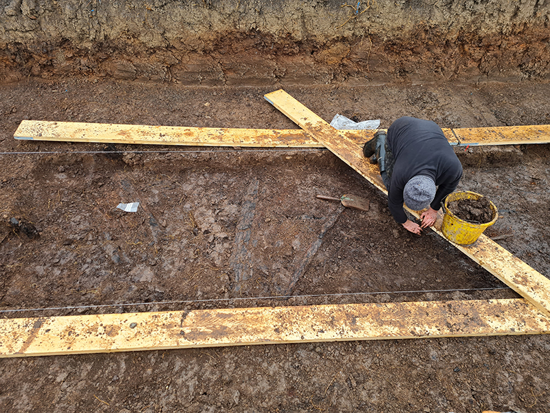
With the bulk of the sediment removed we turned our attention to cleaning up the exposed wood, ready for it to be recorded. This process mainly involved making sure that the extent of every piece of timber could be clearly seen and using gentle sprays of water to both keep the wood wet and to remove any remaining sediment.
Recording is an essential aspect of any archaeological project and the careful method of cleaning and defining the timber that we’ve been describing is the first step in this process. With everything ready in the 1.5m transect by the end of the week, we began using photogrammetry to create a record of the layer of timber.
Photogrammetry is a technique that uses photographs to create measurements between objects and 3D models and is very useful in archaeology. The first stage of this process is to use a good quality camera to take plenty of photos of the archaeology (ideally nice and clean!) from a range of different angles and elevations. However, this is often much easier said than done! Trying to maintain consistent light levels isn’t easy thanks to the very changeable weather of The Fens in the Autumn. Similarly, we also found ourselves taking photographs on a very breezy day and keeping wind-blown debris and soil off the freshly cleaned archaeology was pretty tough.

Photogrammetry in progress. CAU Geomatics Officer Donald Horne gathering images for to be used for the generation of Trench 2’s 3D model.
Thankfully, we managed to take plenty of images which form the basis for the rest of the process. The photos are uploaded into a piece of software which then combines the images together using overlapping pixels. With enough photos that overlap, the software then works out where they were taken and creates a low-density point cloud, which is basically a simple 3D model.
Before photographs are taken a series of target points are placed in and around the trench. These targets are very important and a total station is used to locate them on an Ordnance Survey grid. With this information, the 3D model’s location can be fixed, so we know exactly where the archaeology is in relation to earlier excavations.
A more detailed, dense point cloud is then created before being turned into a mesh. This is then textured, a process which gives the 3D model its visual detail, transforming it into a recognisable visualisation of the archaeology. These 3D models are accurate, to a scale of less than a centimetre, and are very useful as we can use them as the basis for our recording work.

A digital elevation model that is an alternative product from the photogrammetry process. This model allows depths to be seen in a 2D visualisation.
The models can then be used as a basis for further recording in the field. Uploading a plan created from the 3D model onto a tablet allows us to label and record each piece of wood. It’s a faster process than more traditional hand-planning and allows for the project’s plans to be quickly and efficiently updated, which is ideal for this project.
Trench 3 – A New Trench over the Post Alignment
With Trench 2 receiving the photogrammetry treatment on Friday, several of the team moved to Trench 3 to begin the careful process of removing its upper layer of sediment. Trench 3 is also positioned over the post-alignment and will give us another chance to examine the wood associated with this Later Bronze Age archaeological feature.
It’s been another busy week on-site and we’re looking forward to seeing some more of the fantastic Flag Fen archaeology next week.
Project Information
Historic England is funding the project to create a management plan for the protection, understanding and enjoyment of Flag Fen and this historic landscape for generations to come.
The evaluation work is being carried out by the Cambridge Archaeological Unit, finds and conservation assistance is provided by the York Archaeological Trust and the project is supported by Anglian Water, City College Peterborough and City Culture Peterborough.
Digital engagement for the project is kindly supported by the White Rose College of the Arts & Humanities, the AHRC and the University of York, Department for Archaeology.
Flag Fen Blog 2 – Week One
It’s been a very busy first week of the evaluation. In “Week 0”, we brought in a small machine and cut the five trenches that make up the project. This is a very delicate and careful process but we were fortunate enough to have an experienced driver, which made everything much easier. With the machine, we carefully removed the sediment, looking out for the layers we know to sit just above the archaeological level.
In this case, we were looking for a layer of desiccated peat, which previous excavations have shown sit just above the deposits containing the horizontal timbers of the post alignment. As the timber causeway also consisted of large, upright wooden posts, we were fortunate to be able to look out for signs of these emerging. The upper sections of the posts sit above the waterlogged deposits and as such the tops of them can be decayed. This can be helpful to us, as the remaining wood can often be very fibrous and bright orange or brown in colour. Looking out for these signs emerging from the ground as we machine helps us to identify the correct level to machine to and let us know when to break out the hand tools, for some more delicate excavation.
Trench 2 – Post Alignment
As we began our first full week on site, we initially focused on Trench 2, which was placed over the post alignment. Some of our early objectives for the project were to quickly gauge how deep the causeway’s horizontal timbers were, to get a first look at the condition of the wood and to see just how dense the archaeology would be.
The trenches above the post alignment all measure 20x4 metres but we’re focusing on a 1.5m wide transect through the centre of the trench. This transect runs almost the full length of the trench with the space on either side enabling us to move around easily, remove spoil and provide us with good access to the archaeology.
The first horizontal timbers begin to emerge from the sediments in Trench 2.
So, at the beginning of the week we got stuck in! Using shovels, we began cautiously removing the sediments sitting directly above the first layer of horizontals, taking great care to avoid any of the underlying timbers. It’s a gentle process but one that came with immediate results.
Upright posts soon began to emerge from the ground, with small clusters appearing as we moved from the centre of the trench outwards. Small sections of other timbers also began poking through the bottom of the layer. As the week progressed, and more of the overlying deposit was removed, we expanded the team and began the next phase of our exploration.
With hints of the horizontal layer of wood emerging, we began focusing on exposing and defining both the horizontal and upright timbers. This is a very delicate process, as even the best-preserved waterlogged wood is easily marked or damaged. Using a mixture of trowels and wooden implements (usually our favourite repurposed wooden sculpting tools) we carefully remove the sediment from around every piece of timber we encounter. These pieces of wood can vary in size substantially from very large, broad pieces to much smaller and fragile chunks. This variation requires a great deal of care and patience. We’ve also got the temperamental Fenland weather conditions too, which can really make our life challenging.
This steady process of removing sediment followed by defining the top layer of wood occupied most of the week. However, Trench 2 wasn’t the only place we were working.

Exposing more of the timbers in Trench 2. This is a really delicate task, requiring a lot of patience. Thankfully, it’s really satisfying to see the fruits of our labour as the wood appears in the trench.
Trench 5 – Test Pits
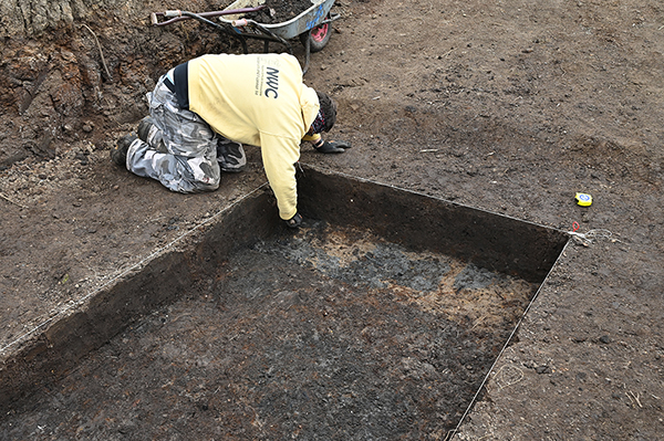
Towards the end of our first week, a few members of the team turned their attention to the trenches designed to evaluate and explore the more enigmatic feature of Flag Fen, the platform. Trench 5 is designed to not only assess the condition of any wood that’s encountered, but to help us understand the extent of the platform.
To achieve this, we’re working in a narrower trench than those above the post alignment, but our excavation strategy is different. To help us determine how far the Flag Fen platform might extend around the site we’re using test pits, spread across two trenches, to dig down and see if we can find evidence of both the posts and horizontal timbers associated with this feature. Within each trench we’re evenly spacing out these 1x1 metre test pits before digging down, to a safe depth, and seeing if we come across wood. If we do find timbers, we’ll move onto the location of the next test pit and repeat the process.
We were keen to begin this process early in the project as the sooner we gather preliminary information, the sooner we can begin to use it to help inform our decisions going forward. So, as we began our first test pit, we were excited but uncertain as to whether we would find wood. It was only at the start of the second day of digging it that we reached a promising looking deposit at the base. Sure enough, with some careful cleaning (not easy, in a 1x1m square!) some timbers appeared, suggesting that we’d found some platform in the bottom of the first test pit.

Starting one of our 1x1m test pits in Trench 5 and pausing at the layers that sit just above the timbers.
After carefully measuring in the next one, close to the end of the trench, we started digging but, as the week ended, we haven’t managed to get quite deep enough to find out whether we may have more platform, or a potential edge!
We’ll have more updates from the project over the coming weeks, both describing our progress, the evaluation and touching on the wider importance of the Flag Fen basin to our understanding of the Later Bronze Age in Britain.
Project Information
Historic England is funding the project to create a management plan for the protection, understanding and enjoyment of Flag Fen and this historic landscape for generations to come.
The evaluation work is being carried out by the Cambridge Archaeological Unit, finds and conservation assistance is provided by the York Archaeological Trust and the project is supported by Anglian Water, City College Peterborough and City Culture Peterborough.
Digital engagement for the project is kindly supported by the White Rose College of the Arts & Humanities, the AHRC and the University of York, Department for Archaeology.
Flag Fen Blog 1 – Introduction and Background
Flag Fen
Flag Fen, located just outside Peterborough, is one of the UK’s most exciting Bronze Age sites. Featuring both a lengthy wooden causeway consisting of aligned upright posts and a more enigmatic timber “platform”, Flag Fen is a rare opportunity for archaeologists to explore some of the more unusual and fascinating aspects of life in Later Bronze Age fenland.
The site was first discovered by Francis Pryor in 1982 following his work undertaking a wider programme of archaeology within the surrounding landscape, the Flag Fen basin. Subsequent excavations have helped us to understand more about the site’s key prehistoric components, the wooden post alignment and the platform.
The post alignment, which has been dated to between 1300 and 900BC, stretches for approximately a kilometre and connects two dryland areas, Northey and Fengate (modern day Whittlesey and Peterborough, respectively). Acting as a causeway, the posts would have created a raised crossing above the marshy, wetland environment. Timbers used in the post alignment consisted of both uprights, which appear to have formed rows, and horizontals, which formed the walkway.
Alongside the wooden causeway, Flag Fen also features a puzzling “platform”, an artificially created island that occurs towards the eastern end of the alignment of timber posts. While this platform has been associated with the deposition of artefacts, its purpose remains unclear.
The Current Project
Since its discovery almost 40 years ago, Flag Fen has benefited from a rich history of archaeological excavation and investigation. The site is a key element of a wider prehistoric landscape and is one of the most nationally significant Bronze Age monuments.
One of the main factors that helps us to understand Flag Fen is the preservation of its large amounts of wood. There are thought to be hundreds of thousands of timbers at the site with recent estimates suggesting there are 22,000 in the post-alignment alone. These 3,000-year-old pieces of wood, from a variety of different species including oak, alder and willow, have survived thanks to the wetland environment of the Fens. The waterlogged sediments around the site have prevented the timbers decaying, allowing us a glimpse into the Later Bronze Age.
Much has changed in the time between the site’s initial discovery in the 1980s and the present day. With time passing and environmental conditions changing, it is very important to examine the archaeology, assess it and use that information to inform future decisions at the site.

Beginning machining on one of the evaluation’s trenches. We use a machine to very carefully remove the upper layers, which can sometimes be several metres deep in the Fens, stopping just above the level of the archaeology. We then dig by hand, or more accurately trowel, to carefully remove the sediment and reveal the timbers.
So, the main aim of this current project is to examine different areas of Flag Fen’s Later Bronze Age archaeology, including the post alignment and the platform, and gauge the preservation and conditions of the wood and associated deposits. Flag Fen has been on Historic England’s Heritage at Risk Register since 2012 and this work is designed to help create a management plan for the future protection and enjoyment of this important landscape.
Unlike large, open area excavations this project is a smaller scale evaluation, carefully designed to target areas and specific archaeological features so we can maximise the information we are able to collect.
To carry out the evaluation, several different types and sizes of trench will be carefully dug to reach and assess the archaeology.
Post Alignment Trenches
Three trenches will be dug to assess the condition of the post alignment/timber causeway. These are designed to look at both the vertical and horizontal timbers.
Platform Trenches
Two trenches will be placed above the timber platform and a series of smaller 1x1m test pits (square slots) dug into the sediment. These test pits are designed to not only determine the condition of the wood but to try and find the extent of the platform, which currently has a very complex edge.
Environmental Test Pit
A small test pit will also be dug to retrieve samples that will be used for the analysis of pollen to help understand the site in relation to the wider Late Bronze Age landscape.
We’ll be going into more detail about each of our trenches over the coming weeks, discussing how we’re excavating them, how they’re informing the project and, of course, what we’re finding!
Project Information
Historic England is funding the project to create a management plan for the protection, understanding and enjoyment of Flag Fen and this historic landscape for generations to come.
The evaluation work is being carried out by the Cambridge Archaeological Unit, finds and conservation assistance is provided by the York Archaeological Trust and the project is supported by Anglian Water, City College Peterborough and City Culture Peterborough.
Digital engagement for the project is kindly supported by the White Rose College of the Arts & Humanities, the AHRC and the University of York, Department for Archaeology.