

The 2009 archaeological field research consisted of three major seasons of work: survey and excavations around the village of Masudpur, Hissar, Haryana and a full-coverage settlement survey of the hinterland of the major Indus urban site of Rakhigarhi.
Excavations at Masudpur I and VII, Hissar, Haryana
The plains of Haryana are relatively flat and have low undulations that are often barely perceptible on the ground. At various points this landscape is interrupted by dunes that are either solitary or part of dune chains that stretch across large areas. A large number of these dunes are visible on the British Period 1 inch to 1 mile maps, and it is notable that many appear to be oriented roughly north-south, which is perpendicular to the typical courses of the ephemeral rivers that traverse the plains of Haryana. There has been some debate over the age of these dunes, but this has not yet been established. Irrespective of their date, these dunes are likely to have been an important geographical factor in the settlement and subsistence strategies used to occupy these plains.
The hydrology of the Haryana plains today is dominated by an extensive modern canal network that draws water from the Sutlej and Yamuna rivers and supplies it to almost every corner of not only Haryana, but also much of northern Rajasthan as well. In addition to the complex canal system, there are also a number of ephemeral water courses that only flow during the periods of winter and summer rain. These include the major channels known as the Chautang, Sarsuti, Markanda, and the Ghaggar, and a large number of other smaller channels and nullahs, and in general they appear to flow in a northeast to southwest direction. The precise age of these ephemeral channels is unknown, but in general they are deeply incised into the plain, often to a depth of 10-15m.

Between 15th and 17th of April 2009, a preliminary reconnaissance was carried out of the region around the modern village of Masudpur. Previous surveys had recorded the existence of four mounds close to the village, which are typically listed as Masudpur I, II, III and IV and given one geographic location, although this has varied (E76 00, N29 14 - Joshi et al. 1984; or E75 58 12, N29 12 47 - Possehl 1999; Kumar 2009). An attempt was made to identify these four mound sites in order to establish their individual geographical locations, but during the reconnaissance, a total of 13 mounds were identified, and many of these appear to have been occupied during the proposed periods of occupation for the previously identified mounds. It was thus impossible to be precise about which mounds corresponded to those that had been previously identified as Masudpur I, II, III and IV, so it was decided to re-number the mounds as MSD I XIII. 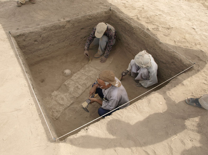
The Masudpur I mound (MSD I), which is known locally as Sampolia Khera, was visited during the survey conducted by members of the Land, Water and Settlement Project in March/April 2008, and at that time it was selected for further investigation as the material recovered from the surface indicated that the site was occupied during the Mature and Late Harappan phases (Singh et al. 2008: 81) . A topographic survey showed that some areas of the mound rise to a height of 3 m above the plain, and in total it covers an area of approximately 6 hectares, suggesting that it was a large village during the proto-historic period. There are clear signs that the mound has been heavily modified for the purposes of agriculture and it is unlikely that any surface of the original mound is currently preserved. The three excavated trenches revealed evidence for local late Early/Sothi Siswal, Middle and Late Harappan occupation.
The Masudpur VII mound (MSD VII), which is known locally as Bhimwada Jodha, was visited during the survey of the Masudpur area conducted by members of the Land, Water and Settlement Project between April 16th and 17th 2009. It was selected for preliminary probing as the material recovered from the surface indicated that the site was occupied during the Early, Mature and Late Harappan phases. Excavations were carried out at MSD VII in two phases, one in April and one in December. A topographic survey showed that some areas of the mound rise to a height of 2.3 m above the plain, and in total it covers an area of approximately 1 hectare, suggesting that it was a small village during the proto-historic period. Unlike Masudpur I, Bhimwada Jodha is relatively well preserved, however all four sides of the mound have been squared by plowing. In both seasons, the lower phases occupation appear to be characterized by locally made Early Harappan/Sothi Siswal ceramics. These are overlain by deposits containing Mature Harappan material, which is in turn overlain by phases characterized by Mature and Late Harappan ceramics. 
The Rakhigarhi Hinterland Survey
The Rakhigarhi Hinterland Survey, Hissar, Haryana
A large number of surveys have been carried out in different parts of Haryana, and these have largely been conducted by MPhil and PhD students from Kurukshetra University and M.D. University in Rohtak (Possehl 1999; Kumar 2009; Chakrabarti and Saini 2009). While there have been attempts to combine the data from these various surveys (e.g. Kumar 2009), there are a number of limitations to these data. In general the surveys have focussed on individual tehsils, blocks and/or districts. As a result of this approach, no survey has used the proto-historic landscape as a basis for its analysis. Areas that have been surveyed intensively typically have high densities of sites (e.g. Dangi 2009a, 2009b), while adjacent areas have often been surveyed in less detail or not at all. The results of the surveys are also somewhat variable, as some have seen the use of GPS equipment to locate sites accurately, while others have relied on locating sites using latitude/longitude (easting/northing) format using degrees and minutes only, resulting in problems of imprecision. There is also the problem of the names attributed to sites. Often the name of the closest village is used to identify several sites, and while they are given separate numbers, there are several instances where only one geographical co-ordinate is given for several sites (e.g. Masudpur I-IV; Joshi et al. 1984; Possehl 1999). When more than one survey has been carried out in a particular area there are often differences in the locations given for particular sites and variant spellings are also common. These limitations result make it difficult to reassess much of the published data.
To establish the geographical context of archaeological sites in the immediate hinterland of Rakhigarhi, and to gain insight into the spatial and temporal variation of sites within this zone, the Land, Water and Settlement Project carried out a systematic village-to-village survey of the area within a 15 km radius of the site in August-September 2009. This has been called the Rakhigarhi Hinterland Survey. A total of 127 sites were located during this survey. Up to 73 of these have not been recorded in previous survey reports and compilations (e.g. Joshi et al. 1984; Possehl 1999; Kumar 2009; Chakrabarti and Saini 2009), meaning that up to 57% of sites within this particular area are new to knowledge. The chronological distribution of these sites is not skewed to any one period, and in all but the Late Harappan phase, up to 50% of sites have not been recorded previously. The Early Historic period has the highest number and proportion of new sites (48 sites, 61.5%. The number of sites dating to each period is as follows: 29 Early Harappan, 15 Mature Harappan, 32 Late Harappan, 18 PGW, 6 NBPW, 78 Early Historic and 26 Mediaeval, with the urban site of Rakhigarhi being occupied only in the Early and Mature Harappan periods.
The sites initially visited in 2009 were revisited in 2014.
Project publications
[1] Singh, R.N., Petrie, C.A., et al. (in press). A preliminary report on the Rakhigarhi Hinterland Survey 2009, BHU and University of Cambridge Archaeological Project, Indian Archaeology: A Review, 2009-2010.
[2] Singh, R.N., Petrie, C.A., et al. (in press). Excavations at Masudpur, Hissar District, Haryana: December 11-17, 2009, BHU and University of Cambridge Archaeological Project, Indian Archaeology: A Review, 2009-2010.
[3] Petrie, C.A. and Singh, R.N. (2009). Land, Water and Settlement in Haryana, India, In: Archaeology at Cambridge 2008–2009, p. 37. Cambridge: McDonald Institute for Archaeological Research.
[4] Singh, R.N., Petrie, C.A. Singh, A.K. and Singh, M. (2009). Excavations at Masudpur (Hissar District, Haryana) 2009: a preliminary report, Bharati, 33: pp. 35–49.
[5] Petrie, C.A., Singh, R.N. and Singh, A.K. (2009). Investigating changing settlement dynamics on the plains: the 2009 survey and excavations at Masudpur (Hissar District, Haryana). Puratattva, 39: pp. 38–49.
[6] Singh, R.N. and Petrie, C.A. (2009). Lost rivers and life on the plains approaches to understanding human/environment interaction between the collapse of Indus urbanism and the rise of the Early Historic cities (The Land, Water and Settlement Project), In: Sarasvati River - A Perspective, Conference Proceedings, Kurukshetra University, Kurukshetra: pp. 102–111.
[7] Singh, R.N. and Petrie, C.A. (2009). Land, Water and Settlement: environmental constraints and human responses in northwest India between 2000 and 300 BC, In: Environment in Ancient India, edited by Singh, H., Naseem, M., Singh, R.N. and Singh, A.K., Monograph of the Department of Ancient Indian History, Culture and Archaeology 21, BHU, Varanasi: pp. 105–108.
[8] Singh, R.N., Petrie, C.A., Pawar, V., Pandey, A.K., Neogi, S., Singh, M., Singh, A.K. Parikh, D. and Lancelotti, C. 2010. Changing patterns of settlement in the rise and fall of Harappan urbanism: preliminary report on the Rakhigarhi Hinterland Survey 2009, Man and Environment 35.1: 37-53.
[9] Singh, R.N., Petrie, C.A., et al. (2015). Excavations at Masudpur, Hissar District, Haryana: April 16 - May 12, 2009, BHU and University of Cambridge Archaeological Project, Indian Archaeology: A Review, 2009-2010: 55-71
[10] Petrie, C.A., Bates, J., Higham, T. and Singh, R.N. (2016). Feeding ancient cities in South Asia: dating the adoption of rice, millet and tropical pulses in the Indus Civilisation, Antiquity 90.354: 1489-1504 [doi: https://doi.org/10.15184/aqy.2016.210].
[11] Joglekar, P.P., Singh, R.N. and Petrie, C.A. (2016). A Preliminary report of animal remains from Bhimwada Jodha (Masudpur VII), Haryana, Bharati 39: 1-9.
[12] Bates, J., Petrie, C.A., and Singh, R.N. (2017). Approaching rice domestication in South Asia: new evidence from Indus settlements in northern India, Journal of Archaeological Science 78: 193-201 [doi: http://dx.doi.org/10.1016/j.jas.2016.04.018].
[13] Bates, J., Singh, R.N. and Petrie, C.A. (2017). Exploring Indus crop processing: combining phytoliths and macrobotanical analysis to consider the organisation of agriculture in northwest India c.3200-1500BC, Vegetation History and Archaeobotany (special issue) 26:25–41 [published online 21 May 2016; DOI http://dx.doi.org/10.1007/s00334-016-0576-9].
[14] Joglekar, P.P., Singh, R.N. and Petrie, C.A. (2017). Faunal Remains from Sampolia Khera (Masudpur I), Haryana, Indian Journal of Archaeology 2.1: 25-60.
Updated:2017-03-24. First published:2008-03-14
Copyright © 2008--2008 Cameron Petrie
Project home page
