
In a study published this week in PNAS, an international team of researchers present the first application combining the use of synthetic-aperture radar (SAR) data and multispectral imagery to detect archaeological mound sites.
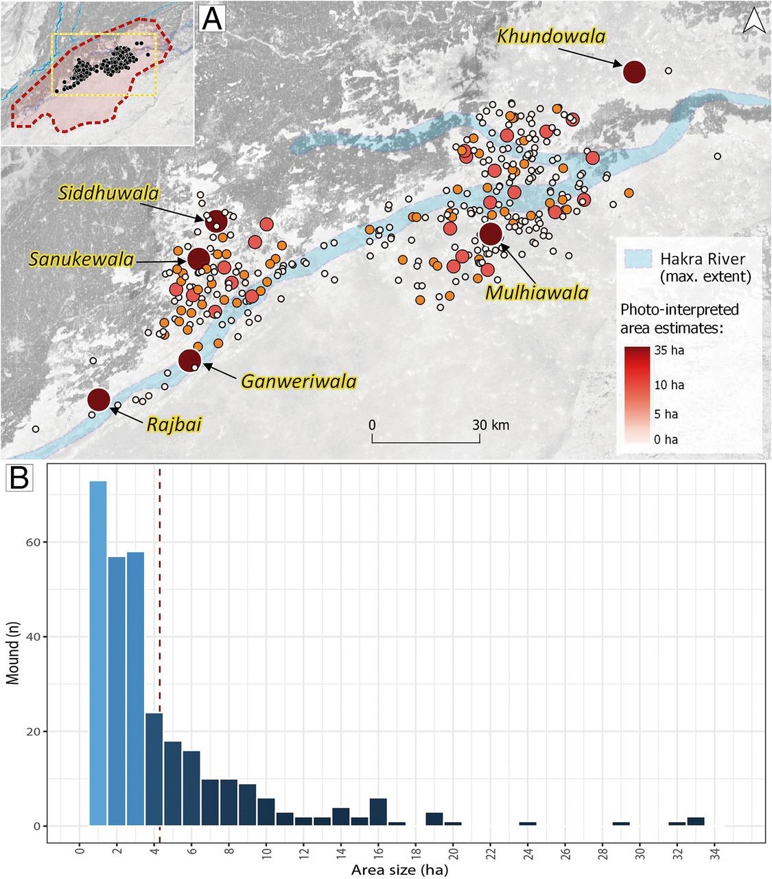
The innovative use of machine learning, a sub-discipline of artificial intelligence, has resulted in the identification of hundreds of archaeological sites situated in the Cholistan Desert area of Pakistan which date to the Indus Civilisation (c. 3300-1500 BC).
Lead author Dr Héctor A. Orengo, researcher at the Catalan Institute of Classical Archaeology (ICAC) said, “Our approach uses multi-temporal data and makes use of imagery produced by joining 1502 SAR and 3127 multispectral images acquired over the last 6 years of the study area in Pakistan.”
“We used known archaeological mound locations in the Cholistan Desert to train a Random Forest classifier in probability mode. The classifier looked for similar signatures to those of the known sites in the combined image composite we created. The result was a highly accurate probability map of mound signatures which extends for over 36000 km2. Our algorithm then isolated mound signatures and extracted them to create a distribution map of possible mounds in the study area.”
“The results largely expand the known concentration of Indus Civilisation (c. 3300-1500 BC) settlements in the Cholistan.”
Senior author Dr Cameron A. Petrie of the Department of Archaeology, University of Cambridge said, “We have detected hundreds of new sites, much deeper in the desert than previously suspected, including several unexpected large-sized urban centres. This makes an important addition to the few other large urban centres for which the Indus Civilisation is known.”
These distribution patterns have major implications regarding the influence of climate change and desertification in the decline of urbanism in this major Old-World complex society.
The patterns suggest that the northern expansion of the Thar desert created an unstable environment and forced the population northwards.
Petrie commented, “Many of these settlements are found alongside palaeoriver channels and these rivers had adapted to dune geomorphology which indicates that during the expansion of the desert the inhabitants had access to seasonal water and tried to adapt to increasingly desert-link conditions. It appears as though ultimately, the desert absorbed large areas of the Cholistan and the area had to be abandoned.”
Orengo concluded, “We believe that the loss of the Cholistan, ideally located in a central position between the different Indus Civilisation areas, was potentially an important factor in the generalised processes of de-urbanisation, decrease in settlement size and regionalisation that characterise the Late Harappan period across the Indus region.”
Not only do these results open new avenues for the analysis of the impact of climate change on past populations, but also, more generally, have the potential to completely transform the ways in which archaeologists carry out their research. Potential sites across extremely large areas can now be detected remotely, before going into the field meaning much more targeted research can be carried out on the ground.
The code for the algorithm has been written in JavaScript to be implemented in Google Earth Engine, which is a geospatial analysis platform linked to Google’s cloud computing resources and provides access to several petabytes of satellite imagery covering the last 40 years. The code is freely available to be used in any other study area and includes detailed instructions for its implementation in Google Earth Engine, which is freely accessible and only requires registration.
The research is published open access in PNAS.
Automated detection of archaeological mounds using machine-learning classification of multisensor and multitemporal satellite data – H. A. Orgengo, F. C. Conesa, A. Garcia-Molsosa, A. Lobo, A. S. Green, M. Madella and C. A. Petrie. Proceedings of the National Academy of Sciences Jul 2020, 202005583; DOI: https://doi.org/10.1073/pnas.2005583117


